Land Area Measurement: Method, Tools, and Process
Addressofchoice 11 August 2022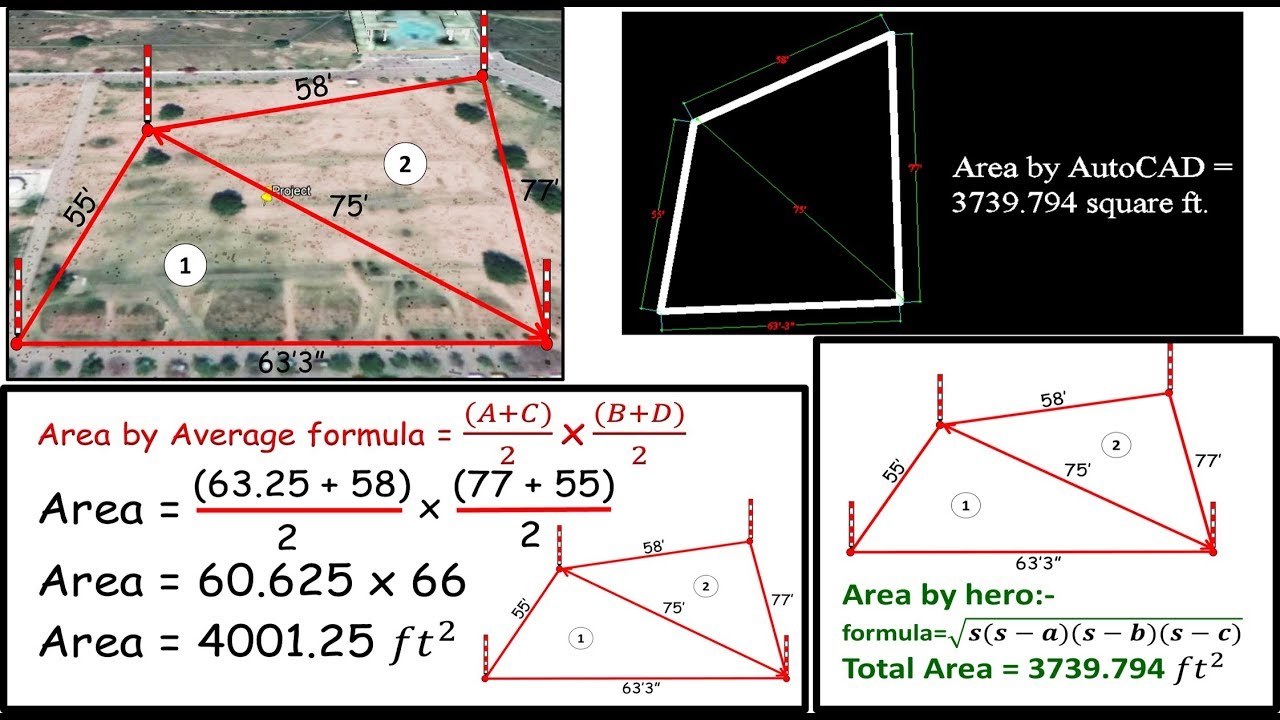
Land Area Measurement
Measurement of the land may be necessary not only when purchasing it (which is one of the most common situations) but also in disputes, division of lots, donations and inheritance. Depending on the method used and the required accuracy, the land area measurement can be determined independently and with a geodetic expert's participation.
Suppose the information you receive is not official and is required only for personal use (clarification of boundaries, division of the site according to the purpose of service). In that case, it makes sense to measure the land yourself. However, in the event of a land dispute with a neighbor, if you need to prepare documents when buying or selling, and if you plan to develop, you must involve a qualified land surveyor.
They are free to use the equipment to measure the appropriate accuracy and the authority to allow the company's investigative experts to establish the basic formal procedures for resolving controversial issues. I can do it. It is he who subsequently becomes legally weighted evidence.
Methods for Determining the Area
The analytical method of determination helps to field area measure by measuring angles and sides. If the site is too large, it can be divided into several squares called polygons.
The graphical method has a topographic basis. The basis of such measurements is a map, on which, using the scale, measurements are taken of the site or polygons of which it consists.
The mechanical method is more modern and efficient. Determining the area of ??a land plot occurs through the use of auxiliary instruments and devices.
It happens that for the correct measurements of the area of ??\u200b\u200bthe site, all three methods are used simultaneously, combining means to achieve the most accurate result. The site size can also be calculated on a computer by generating a digital terrain model and summing all the necessary indicators.
Land Area Measurement
Before proceeding directly to the land area measurement, it is necessary to clarify the allocation form. The easiest way is if the site is rectangular or square without irregular bends. However, they often have sharp corners and beveled edges along edges. It is also essential to consider that the surface always has depressions, heights, and irregularities, but to determine the dimensions, the length along the surface is not taken into account, but the projection of the profile on the horizontal plane. The parameters are as follows: was taken.
Even if the surface looks completely flat, check it first. To do this, clear the line of tall grass and other possible obstructions before measuring the site area, then move the stake to that corner. One of the bets will be marked, and then the remaining bets will be kept in the same way using the water level. Then, according to the obtained mark, the thread is fixed at the previously obtained point, and the thread is pulled out.
To get a clear area, record the length of the edges around the plot. However, it is essential to remember. The visually correct dress form is rarely accurate. Therefore, it is worth carrying out an operation similar to measuring the earth's circumference to determine the diameter. Still, in this case, the pegs are placed at 2-4 m.
Then to determine the area, use the formulas in the school geometry course, divide the fake numbers into several whole numbers and sum the results. The most important are rectangles (the length must be multiplied by the width to calculate area) and right triangles. In the second case, the site is determined as half the product of the sides perpendicular to each other.
Land Measurement Tools
The latest technologies are actively used to create specialized tools due to the need to obtain highly accurate data when performing geodetic operations. In most cases, electronic tachometers, distance meters, and measuring wheels are used when land measurement works are carried out.
Tachometer - A tachometer is a device for measuring vertical and horizontal distance and angles. With their help, you can easily and accurately determine the height and coordinates of a certain point. This is necessary for terrain surveys, marking, and cadastral and land management tasks.
Laser Rangefinders - Laser rangefinders are also commonly used electronic devices to measure the electromagnetic section of the optical spectrum. It is divided into two groups and can be temporary or gradual. In the first case, the distance is measured based on the delay time, and in the latter case, it is measured based on the phase shift of the reflected signal. As the name suggests, a non-reflective rangefinder can also be used and work without a reflector.
Measuring wheel - The measuring wheel becomes a mechanical counter for the distance traveled during the batch. With it, you can get precise results with a straightforward operating principle. Structurally, such devices include a particular calibration wheel that rotates along the measured line. The result is obtained immediately after processing the data received from the specific counter. Each of these units has a well-defined diameter, so to get the length, multiply the wheel's diameter by the unit's number of revolutions.
The most accurate method is to determine the area that involves work directly on the ground and to use mathematical formulas and the laws of geometry to determine the length of lines and angles. In this case, the accuracy of the results depends only on the error in measuring the distance on the ground. For example, when you use a ready-made graph for these purposes, an error occurs during the plan's creation.
Take the help of a professional surveyor for land area measurement.
Indeed you think calculating your plot's area is a simple mathematical operation? At first sight, yes, since, in theory, it suffices to multiply its length by its width. But the reality is different; the operation becomes much more complex without the right measuring instruments. This is why the safest way to calculate the area of ??your land is to call on the services of a surveyor. Why?
Conclusion: The most accurate method available is that of demarcation of your land. Demarcation is an operation that defines the limits of your land about neighboring plots with extreme precision. Only an expert surveyor can carry out a land demarcation. He has both the technical skills and the right equipment.


Addressofchoice
https://www.addressofchoice.com/Address Of Choice is an online real estate consulting firm, who workes in across India. AOC deals in residential and commercial properties.
Get in Touch With us
Register here and Avail the Best Offers!!